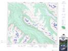
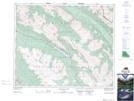
Maps showing Maligne Range, 43-26-W5, Alberta
Maligne Range is a Mountain located in 43-26-W5, Alberta and has an elevation of 2333 meters.
- Latitude: 52° 46' 59'' North (decimal: 52.7830555)
- Longitude: 117° 47' 44'' West (decimal: -117.7955556)
- Topography Feature Category: Mountain
- Geographical Feature: Range
- Canadian Province/Territory: Alberta
- Elevation: 2333 meters
- Location: 43-26-W5
- Atlas of Canada Locator Map: Maligne Range
- GPS Coordinate Locator Map: Maligne Range Lat/Long
Maligne Range NTS Map Sheets