Maps showing Saunders, 24-40-13-W5, Alberta
Saunders is a Unincorporated area located in 24-40-13-W5, Alberta and has an elevation of 1201 meters.
- Latitude: 52° 27' 32'' North (decimal: 52.4588888)
- Longitude: 115° 43' 26'' West (decimal: -115.7238888)
- Topography Feature Category: Unincorporated area
- Geographical Feature: Locality
- Canadian Province/Territory: Alberta
- Elevation: 1201 meters
- Location: 24-40-13-W5
- Atlas of Canada Locator Map: Saunders
- GPS Coordinate Locator Map: Saunders Lat/Long
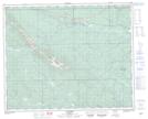
Saunders NTS Map Sheets