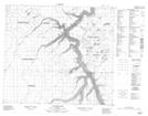
Maps showing Grand Island, 34-84-17-W4, Alberta
Grand Island is a Island located in 34-84-17-W4, Alberta and has an elevation of 397 meters.
- Latitude: 56° 19' 45'' North (decimal: 56.3291667)
- Longitude: 112° 36' 36'' West (decimal: -112.6100000)
- Topography Feature Category: Island
- Geographical Feature: Island
- Canadian Province/Territory: Alberta
- Elevation: 397 meters
- Location: 34-84-17-W4
- Atlas of Canada Locator Map: Grand Island
- GPS Coordinate Locator Map: Grand Island Lat/Long
Grand Island NTS Map Sheets