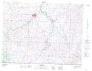
Maps showing Mary Lake, 12-1-25-W4, Alberta
Mary Lake is a Lake located in 12-1-25-W4, Alberta and has an elevation of 1275 meters.
- Latitude: 49° 1' 9'' North (decimal: 49.0191666)
- Longitude: 113° 12' 30'' West (decimal: -113.2083333)
- Topography Feature Category: Lake
- Geographical Feature: Lake
- Canadian Province/Territory: Alberta
- Elevation: 1275 meters
- Location: 12-1-25-W4
- Atlas of Canada Locator Map: Mary Lake
- GPS Coordinate Locator Map: Mary Lake Lat/Long
Mary Lake NTS Map Sheets