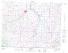
Maps showing Breast Work Hill, 20,21-3-26-W4, Alberta
Breast Work Hill is a Mountain located in 20,21-3-26-W4, Alberta and has an elevation of 1201 meters.
- Latitude: 49° 13' 33'' North (decimal: 49.2258333)
- Longitude: 113° 27' 13'' West (decimal: -113.4536110)
- Topography Feature Category: Mountain
- Geographical Feature: Hill
- Canadian Province/Territory: Alberta
- Elevation: 1201 meters
- Location: 20,21-3-26-W4
- Atlas of Canada Locator Map: Breast Work Hill
- GPS Coordinate Locator Map: Breast Work Hill Lat/Long
Breast Work Hill NTS Map Sheets