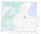
Maps showing Shonts, 21-50-18-W4, Alberta
Shonts is a Unincorporated area located in 21-50-18-W4, Alberta and has an elevation of 679 meters.
- Latitude: 53° 19' 40'' North (decimal: 53.3277777)
- Longitude: 112° 34' 2'' West (decimal: -112.5672222)
- Topography Feature Category: Unincorporated area
- Geographical Feature: Locality
- Canadian Province/Territory: Alberta
- Elevation: 679 meters
- Location: 21-50-18-W4
- Atlas of Canada Locator Map: Shonts
- GPS Coordinate Locator Map: Shonts Lat/Long