Canada Topographic Maps

Shunda Creek Topo Maps

Topography maps and Latitude/Longitude Location

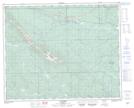
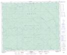
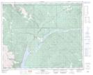
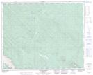
Maps showing Shunda Creek, 40-13-W5, Alberta

Shunda Creek is a River located in 40-13-W5, Alberta and has an elevation of 1161 meters.

  • Latitude: 52° 27' 19'' North   (decimal: 52.4552777)
  • Longitude: 115° 46' 44'' West   (decimal: -115.7788889)
  • Topography Feature Category: River
  • Geographical Feature: Creek
  • Canadian Province/Territory: Alberta
  • Elevation: 1161 meters
  • Location: 40-13-W5
  • Atlas of Canada Locator Map: Shunda Creek
  • GPS Coordinate Locator Map: Shunda Creek Lat/Long

Shunda Creek NTS Map Sheets

083B05 Saunders Topographic Map at 1:50,000 scale

083B12 Harlech Topographic Map at 1:50,000 scale

083C08 Nordegg Topographic Map at 1:50,000 scale

083C09 Wapiabi Creek Topographic Map at 1:50,000 scale

083B Rocky Mountain House Topographic Map at 1:250,000 scale

083C Brazeau Lake Topographic Map at 1:250,000 scale

 
Buy Topographic Maps DVD
Newsletter Sign-up

Yes, I want to receive map store discounts.


Bookmark and Share