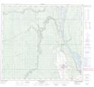
Maps showing Haight Island, 94,95-11-W4, Alberta
Haight Island is a Island located in 94,95-11-W4, Alberta and has an elevation of 238 meters.
- Latitude: 57° 12' 15'' North (decimal: 57.2041666)
- Longitude: 111° 37' 3'' West (decimal: -111.6174999)
- Topography Feature Category: Island
- Geographical Feature: Island
- Canadian Province/Territory: Alberta
- Elevation: 238 meters
- Location: 94,95-11-W4
- Atlas of Canada Locator Map: Haight Island
- GPS Coordinate Locator Map: Haight Island Lat/Long
Haight Island NTS Map Sheets