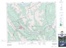
Maps showing Harvie Heights, 7,18-25-10-W5, Alberta
Harvie Heights is a Unincorporated area located in 7,18-25-10-W5, Alberta and has an elevation of 1358 meters.
- Latitude: 51° 7' 31'' North (decimal: 51.1252777)
- Longitude: 115° 23' 6'' West (decimal: -115.3849999)
- Topography Feature Category: Unincorporated area
- Geographical Feature: Hamlet
- Canadian Province/Territory: Alberta
- Elevation: 1358 meters
- Location: 7,18-25-10-W5
- Atlas of Canada Locator Map: Harvie Heights
- GPS Coordinate Locator Map: Harvie Heights Lat/Long