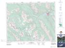
Maps showing Healy Pass, 24-14-W5, Alberta
Healy Pass is a Valley located in 24-14-W5, Alberta and has an elevation of 2303 meters.
- Latitude: 51° 5' 32'' North (decimal: 51.0922222)
- Longitude: 115° 52' 3'' West (decimal: -115.8674999)
- Topography Feature Category: Valley
- Geographical Feature: Pass
- Canadian Province/Territory: Alberta
- Elevation: 2303 meters
- Location: 24-14-W5
- Atlas of Canada Locator Map: Healy Pass
- GPS Coordinate Locator Map: Healy Pass Lat/Long