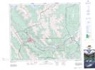
Maps showing Bow Valley Provincial Park, 24-8-W5, Alberta
Bow Valley Provincial Park is a Conservation area located in 24-8-W5, Alberta and has an elevation of 1314 meters.
- Latitude: 51° 4' 31'' North (decimal: 51.0752778)
- Longitude: 115° 4' 9'' West (decimal: -115.0691666)
- Topography Feature Category: Conservation area
- Geographical Feature: Provincial Park
- Canadian Province/Territory: Alberta
- Elevation: 1314 meters
- Location: 24-8-W5
- Atlas of Canada Locator Map: Bow Valley Provincial Park
- GPS Coordinate Locator Map: Bow Valley Provincial Park Lat/Long