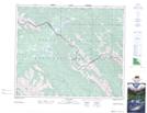
Maps showing Snake Indian Falls, 50-2-W6, Alberta
Snake Indian Falls is a Falls located in 50-2-W6, Alberta and has an elevation of 1277 meters.
- Latitude: 53° 17' 32'' North (decimal: 53.2922222)
- Longitude: 118° 16' 24'' West (decimal: -118.2733333)
- Topography Feature Category: Falls
- Geographical Feature: Falls
- Canadian Province/Territory: Alberta
- Elevation: 1277 meters
- Location: 50-2-W6
- Atlas of Canada Locator Map: Snake Indian Falls
- GPS Coordinate Locator Map: Snake Indian Falls Lat/Long
Snake Indian Falls NTS Map Sheets