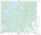
Maps showing Snug Cove, 19-65-9-W4, Alberta
Snug Cove is a Unincorporated area located in 19-65-9-W4, Alberta and has an elevation of 604 meters.
- Latitude: 54° 38' 31'' North (decimal: 54.6419444)
- Longitude: 111° 20' 29'' West (decimal: -111.3413889)
- Topography Feature Category: Unincorporated area
- Geographical Feature: Locality
- Canadian Province/Territory: Alberta
- Elevation: 604 meters
- Location: 19-65-9-W4
- Atlas of Canada Locator Map: Snug Cove
- GPS Coordinate Locator Map: Snug Cove Lat/Long
Snug Cove NTS Map Sheets