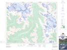
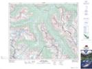
Maps showing Solitaire Mountain, 32-21-W5, Alberta
Solitaire Mountain is a Mountain located in 32-21-W5, Alberta and has an elevation of 2890 meters.
- Latitude: 51° 45' 2'' North (decimal: 51.7505555)
- Longitude: 116° 50' 28'' West (decimal: -116.8411110)
- Topography Feature Category: Mountain
- Geographical Feature: Mountain
- Canadian Province/Territory: Alberta
- Elevation: 2890 meters
- Location: 32-21-W5
- Atlas of Canada Locator Map: Solitaire Mountain
- GPS Coordinate Locator Map: Solitaire Mountain Lat/Long
Solitaire Mountain NTS Map Sheets