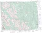
Maps showing Mount Hoffman, 18-19-5-W5, Alberta
Mount Hoffman is a Mountain located in 18-19-5-W5, Alberta and has an elevation of 1902 meters.
- Latitude: 50° 36' 17'' North (decimal: 50.6047222)
- Longitude: 114° 41' 24'' West (decimal: -114.6899999)
- Topography Feature Category: Mountain
- Geographical Feature: Mount
- Canadian Province/Territory: Alberta
- Elevation: 1902 meters
- Location: 18-19-5-W5
- Atlas of Canada Locator Map: Mount Hoffman
- GPS Coordinate Locator Map: Mount Hoffman Lat/Long
Mount Hoffman NTS Map Sheets