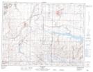
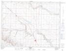
Maps showing Milk River Ridge Reservoir, 4,5-19,20-W4, Alberta
Milk River Ridge Reservoir is a Lake located in 4,5-19,20-W4, Alberta and has an elevation of 1034 meters.
- Latitude: 49° 22' 29'' North (decimal: 49.3747222)
- Longitude: 112° 35' 43'' West (decimal: -112.5952778)
- Topography Feature Category: Lake
- Geographical Feature: Reservoir
- Canadian Province/Territory: Alberta
- Elevation: 1034 meters
- Location: 4,5-19,20-W4
- Atlas of Canada Locator Map: Milk River Ridge Reservoir
- GPS Coordinate Locator Map: Milk River Ridge Reservoir Lat/Long
Milk River Ridge Reservoir NTS Map Sheets