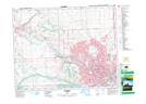
Maps showing Spy Hill, 28-25-2-W5, Alberta
Spy Hill is a Mountain located in 28-25-2-W5, Alberta and has an elevation of 1265 meters.
- Latitude: 51° 9' 25'' North (decimal: 51.1568999)
- Longitude: 114° 13' 27'' West (decimal: -114.2242000)
- Topography Feature Category: Mountain
- Geographical Feature: Hill
- Canadian Province/Territory: Alberta
- Elevation: 1265 meters
- Location: 28-25-2-W5
- Atlas of Canada Locator Map: Spy Hill
- GPS Coordinate Locator Map: Spy Hill Lat/Long