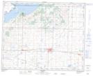
Maps showing Stettler, 5-39-19-W4, Alberta
Stettler is a Town located in 5-39-19-W4, Alberta and has an elevation of 817 meters.
- Latitude: 52° 19' 26'' North (decimal: 52.3238888)
- Longitude: 112° 42' 16'' West (decimal: -112.7044443)
- Topography Feature Category: Town
- Geographical Feature: Town
- Canadian Province/Territory: Alberta
- Elevation: 817 meters
- Location: 5-39-19-W4
- Atlas of Canada Locator Map: Stettler
- GPS Coordinate Locator Map: Stettler Lat/Long