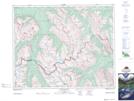
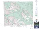
Maps showing Indianhead Creek, 33-15-W5, Alberta
Indianhead Creek is a River located in 33-15-W5, Alberta and has an elevation of 1936 meters.
- Latitude: 51° 50' 25'' North (decimal: 51.8402777)
- Longitude: 115° 59' 41'' West (decimal: -115.9947221)
- Topography Feature Category: River
- Geographical Feature: Creek
- Canadian Province/Territory: Alberta
- Elevation: 1936 meters
- Location: 33-15-W5
- Atlas of Canada Locator Map: Indianhead Creek
- GPS Coordinate Locator Map: Indianhead Creek Lat/Long
Indianhead Creek NTS Map Sheets