Maps showing Chedderville, 17-37-6-W5, Alberta
Chedderville is a Unincorporated area located in 17-37-6-W5, Alberta and has an elevation of 1068 meters.
- Latitude: 52° 10' 27'' North (decimal: 52.1741666)
- Longitude: 114° 50' 4'' West (decimal: -114.8344443)
- Topography Feature Category: Unincorporated area
- Geographical Feature: Locality
- Canadian Province/Territory: Alberta
- Elevation: 1068 meters
- Location: 17-37-6-W5
- Atlas of Canada Locator Map: Chedderville
- GPS Coordinate Locator Map: Chedderville Lat/Long
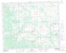
Chedderville NTS Map Sheets