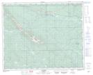
Maps showing Stolberg, 32-40-13-W5, Alberta
Stolberg is a Unincorporated area located in 32-40-13-W5, Alberta.
- Latitude: 52° 28' 43'' North (decimal: 52.4786110)
- Longitude: 115° 49' 30'' West (decimal: -115.8250000)
- Topography Feature Category: Unincorporated area
- Geographical Feature: Locality
- Canadian Province/Territory: Alberta
- Location: 32-40-13-W5
- Atlas of Canada Locator Map: Stolberg
- GPS Coordinate Locator Map: Stolberg Lat/Long
Stolberg NTS Map Sheets