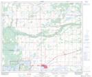
Maps showing Iron River, 18-63-6-W4, Alberta
Iron River is a Unincorporated area located in 18-63-6-W4, Alberta and has an elevation of 565 meters.
- Latitude: 54° 26' 29'' North (decimal: 54.4413888)
- Longitude: 110° 54' 32'' West (decimal: -110.9088889)
- Topography Feature Category: Unincorporated area
- Geographical Feature: Locality
- Canadian Province/Territory: Alberta
- Elevation: 565 meters
- Location: 18-63-6-W4
- Atlas of Canada Locator Map: Iron River
- GPS Coordinate Locator Map: Iron River Lat/Long
Iron River NTS Map Sheets