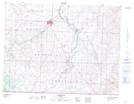
Maps showing Jefferson, 36-1-24-W4, Alberta
Jefferson is a Unincorporated area located in 36-1-24-W4, Alberta.
- Latitude: 49° 5' North (decimal: 49.0832999)
- Longitude: 113° 5' West (decimal: -113.0833000)
- Topography Feature Category: Unincorporated area
- Geographical Feature: Locality
- Canadian Province/Territory: Alberta
- Location: 36-1-24-W4
- Atlas of Canada Locator Map: Jefferson
- GPS Coordinate Locator Map: Jefferson Lat/Long
Jefferson NTS Map Sheets