Maps showing Mural Glacier, 49-8,9-W6, Alberta
Mural Glacier is a Glacier located in 49-8,9-W6, Alberta and has an elevation of 2383 meters.
- Latitude: 53° 11' 37'' North (decimal: 53.1936111)
- Longitude: 119° 10' 42'' West (decimal: -119.1783332)
- Topography Feature Category: Glacier
- Geographical Feature: Glacier
- Canadian Province/Territory: Alberta
- Elevation: 2383 meters
- Location: 49-8,9-W6
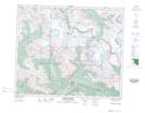
- Atlas of Canada Locator Map: Mural Glacier
- GPS Coordinate Locator Map: Mural Glacier Lat/Long
Mural Glacier NTS Map Sheets