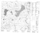
Maps showing Namur Lake, 97-17-W4, Alberta
Namur Lake is a Lake located in 97-17-W4, Alberta.
- Latitude: 57° 25' 2'' North (decimal: 57.4172222)
- Longitude: 112° 40' 59'' West (decimal: -112.6830556)
- Topography Feature Category: Lake
- Geographical Feature: Lake
- Canadian Province/Territory: Alberta
- Location: 97-17-W4
- Atlas of Canada Locator Map: Namur Lake
- GPS Coordinate Locator Map: Namur Lake Lat/Long
Namur Lake NTS Map Sheets