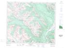
Maps showing Mount Oliver, 47-3-W6, Alberta
Mount Oliver is a Mountain located in 47-3-W6, Alberta and has an elevation of 2629 meters.
- Latitude: 53° 1' 9'' North (decimal: 53.0191666)
- Longitude: 118° 21' 2'' West (decimal: -118.3505556)
- Topography Feature Category: Mountain
- Geographical Feature: Mount
- Canadian Province/Territory: Alberta
- Elevation: 2629 meters
- Location: 47-3-W6
- Atlas of Canada Locator Map: Mount Oliver
- GPS Coordinate Locator Map: Mount Oliver Lat/Long
Mount Oliver NTS Map Sheets