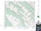
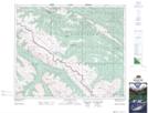
Maps showing Climax Creek, 45-25-W5, Alberta
Climax Creek is a River located in 45-25-W5, Alberta and has an elevation of 1566 meters.
- Latitude: 52° 53' 10'' North (decimal: 52.8861670)
- Longitude: 117° 30' 11'' West (decimal: -117.5030560)
- Topography Feature Category: River
- Geographical Feature: Creek
- Canadian Province/Territory: Alberta
- Elevation: 1566 meters
- Location: 45-25-W5
- Atlas of Canada Locator Map: Climax Creek
- GPS Coordinate Locator Map: Climax Creek Lat/Long
Climax Creek NTS Map Sheets