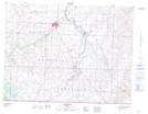
Maps showing Coal Canyon, 22-1-25-W4, Alberta
Coal Canyon is a Valley located in 22-1-25-W4, Alberta.
- Latitude: 49° 3' 0'' North (decimal: 49.0500000)
- Longitude: 113° 15' 10'' West (decimal: -113.2528000)
- Topography Feature Category: Valley
- Geographical Feature: Canyon
- Canadian Province/Territory: Alberta
- Location: 22-1-25-W4
- GPS Coordinate Locator Map: Coal Canyon Lat/Long
Coal Canyon NTS Map Sheets