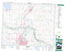
Maps showing College Heights, 31-40-26-W4, Alberta
College Heights is a Unincorporated area located in 31-40-26-W4, Alberta and has an elevation of 860 meters.
- Latitude: 52° 29' 21'' North (decimal: 52.4891666)
- Longitude: 113° 44' 00'' West (decimal: -113.7333333)
- Topography Feature Category: Unincorporated area
- Geographical Feature: Hamlet
- Canadian Province/Territory: Alberta
- Elevation: 860 meters
- Location: 31-40-26-W4
- Atlas of Canada Locator Map: College Heights
- GPS Coordinate Locator Map: College Heights Lat/Long