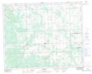
Maps showing Congresbury, 32-37-7-W5, Alberta
Congresbury is a Unincorporated area located in 32-37-7-W5, Alberta.
- Latitude: 52° 14' North (decimal: 52.2333333)
- Longitude: 114° 58' West (decimal: -114.9666667)
- Topography Feature Category: Unincorporated area
- Geographical Feature: Locality
- Canadian Province/Territory: Alberta
- Location: 32-37-7-W5
- Atlas of Canada Locator Map: Congresbury
- GPS Coordinate Locator Map: Congresbury Lat/Long
Congresbury NTS Map Sheets