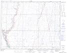
Maps showing Control, 6-24-14-W4, Alberta
Control is a Unincorporated area located in 6-24-14-W4, Alberta.
- Latitude: 51° 1' 4'' North (decimal: 51.0177777)
- Longitude: 111° 57' 11'' West (decimal: -111.9530556)
- Topography Feature Category: Unincorporated area
- Geographical Feature: Railway Point
- Canadian Province/Territory: Alberta
- Location: 6-24-14-W4
- Atlas of Canada Locator Map: Control
- GPS Coordinate Locator Map: Control Lat/Long