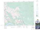
Maps showing Mount Costigan, 27-10-W5, Alberta
Mount Costigan is a Mountain located in 27-10-W5, Alberta and has an elevation of 2750 meters.
- Latitude: 51° 17' 8'' North (decimal: 51.2855555)
- Longitude: 115° 16' 55'' West (decimal: -115.2819444)
- Topography Feature Category: Mountain
- Geographical Feature: Mount
- Canadian Province/Territory: Alberta
- Elevation: 2750 meters
- Location: 27-10-W5
- Atlas of Canada Locator Map: Mount Costigan
- GPS Coordinate Locator Map: Mount Costigan Lat/Long
Mount Costigan NTS Map Sheets