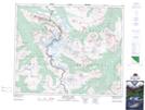
Maps showing Tonquin Valley, 43-2-W6, Alberta
Tonquin Valley is a Valley located in 43-2-W6, Alberta and has an elevation of 2037 meters.
- Latitude: 52° 43' 5'' North (decimal: 52.7180555)
- Longitude: 118° 16' 4'' West (decimal: -118.2677778)
- Topography Feature Category: Valley
- Geographical Feature: Valley
- Canadian Province/Territory: Alberta
- Elevation: 2037 meters
- Location: 43-2-W6
- Atlas of Canada Locator Map: Tonquin Valley
- GPS Coordinate Locator Map: Tonquin Valley Lat/Long
Tonquin Valley NTS Map Sheets