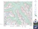
Maps showing Totem Tower, Alberta
Totem Tower is a Mountain located in Alberta and has an elevation of 2659 meters.
- Latitude: 51° 53' 31'' North (decimal: 51.8919444)
- Longitude: 116° 36' 28'' West (decimal: -116.6077778)
- Topography Feature Category: Mountain
- Geographical Feature: Tower
- Canadian Province/Territory: Alberta
- Elevation: 2659 meters
- Atlas of Canada Locator Map: Totem Tower
- GPS Coordinate Locator Map: Totem Tower Lat/Long
Totem Tower NTS Map Sheets