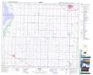
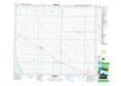
Maps showing Vegreville, 18-52-14-W4, Alberta
Vegreville is a Town located in 18-52-14-W4, Alberta and has an elevation of 638 meters.
- Latitude: 53° 29' 44'' North (decimal: 53.4955555)
- Longitude: 112° 3' 6'' West (decimal: -112.0516667)
- Topography Feature Category: Town
- Geographical Feature: Town
- Canadian Province/Territory: Alberta
- Elevation: 638 meters
- Location: 18-52-14-W4
- Atlas of Canada Locator Map: Vegreville
- GPS Coordinate Locator Map: Vegreville Lat/Long
Vegreville NTS Map Sheets