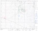
Maps showing Nose Hill, 37-8,9-W4, Alberta
Nose Hill is a Mountain located in 37-8,9-W4, Alberta and has an elevation of 854 meters.
- Latitude: 52° 9' 14'' North (decimal: 52.1538888)
- Longitude: 111° 8' 34'' West (decimal: -111.1427778)
- Topography Feature Category: Mountain
- Geographical Feature: Hill
- Canadian Province/Territory: Alberta
- Elevation: 854 meters
- Location: 37-8,9-W4
- Atlas of Canada Locator Map: Nose Hill
- GPS Coordinate Locator Map: Nose Hill Lat/Long
Nose Hill NTS Map Sheets