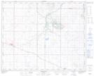
Maps showing Veteran, 17-35-8-W4, Alberta
Veteran is a Village located in 17-35-8-W4, Alberta and has an elevation of 798 meters.
- Latitude: 52° 0' 10'' North (decimal: 52.0027778)
- Longitude: 111° 7' 15'' West (decimal: -111.1208333)
- Topography Feature Category: Village
- Geographical Feature: Village
- Canadian Province/Territory: Alberta
- Elevation: 798 meters
- Location: 17-35-8-W4
- Atlas of Canada Locator Map: Veteran
- GPS Coordinate Locator Map: Veteran Lat/Long
Veteran NTS Map Sheets