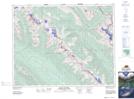
Maps showing Vista Lake, 26-15-W5, Alberta
Vista Lake is a Lake located in 26-15-W5, Alberta and has an elevation of 1656 meters.
- Latitude: 51° 14' 17'' North (decimal: 51.2380555)
- Longitude: 116° 1' 28'' West (decimal: -116.0244443)
- Topography Feature Category: Lake
- Geographical Feature: Lake
- Canadian Province/Territory: Alberta
- Elevation: 1656 meters
- Location: 26-15-W5
- Atlas of Canada Locator Map: Vista Lake
- GPS Coordinate Locator Map: Vista Lake Lat/Long
Vista Lake NTS Map Sheets