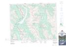
Maps showing Warridge Creek, Alberta
Warridge Creek is a River located in Alberta.
- Latitude: 50° 52' North (decimal: 50.8667000)
- Longitude: 115° 24' West (decimal: -115.3999999)
- Topography Feature Category: River
- Geographical Feature: Creek
- Canadian Province/Territory: Alberta
- GPS Coordinate Locator Map: Warridge Creek Lat/Long
Warridge Creek NTS Map Sheets