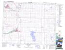
Maps showing Aldersyde, 7-20-28-W4, Alberta
Aldersyde is a Unincorporated area located in 7-20-28-W4, Alberta and has an elevation of 1041 meters.
- Latitude: 50° 40' 34'' North (decimal: 50.6761111)
- Longitude: 113° 52' 44'' West (decimal: -113.8788889)
- Topography Feature Category: Unincorporated area
- Geographical Feature: Hamlet
- Canadian Province/Territory: Alberta
- Elevation: 1041 meters
- Location: 7-20-28-W4
- Atlas of Canada Locator Map: Aldersyde
- GPS Coordinate Locator Map: Aldersyde Lat/Long
Aldersyde NTS Map Sheets