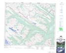
Maps showing Brewster's Wall, 52-6,7-W6, Alberta
Brewster's Wall is a Cliff located in 52-6,7-W6, Alberta.
- Latitude: 53° 28' 14'' North (decimal: 53.4705555)
- Longitude: 118° 53' 16'' West (decimal: -118.8877777)
- Topography Feature Category: Cliff
- Geographical Feature: Wall
- Canadian Province/Territory: Alberta
- Location: 52-6,7-W6
- Atlas of Canada Locator Map: Brewster's Wall
- GPS Coordinate Locator Map: Brewster's Wall Lat/Long
Brewster's Wall NTS Map Sheets