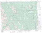
Maps showing Elbow Falls, 16-22-6-W5, Alberta
Elbow Falls is a Falls located in 16-22-6-W5, Alberta.
- Latitude: 50° 52' 3'' North (decimal: 50.8674999)
- Longitude: 114° 46' 4'' West (decimal: -114.7677778)
- Topography Feature Category: Falls
- Geographical Feature: Falls
- Canadian Province/Territory: Alberta
- Location: 16-22-6-W5
- Atlas of Canada Locator Map: Elbow Falls
- GPS Coordinate Locator Map: Elbow Falls Lat/Long
Elbow Falls NTS Map Sheets