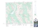
Maps showing Troll Falls, 16-11-23-9-W5, Alberta
Troll Falls is a Falls located in 16-11-23-9-W5, Alberta and has an elevation of 1516 meters.
- Latitude: 50° 56' 53'' North (decimal: 50.9480555)
- Longitude: 115° 8' 40'' West (decimal: -115.1444443)
- Topography Feature Category: Falls
- Geographical Feature: Falls
- Canadian Province/Territory: Alberta
- Elevation: 1516 meters
- Location: 16-11-23-9-W5
- Atlas of Canada Locator Map: Troll Falls
- GPS Coordinate Locator Map: Troll Falls Lat/Long
Troll Falls NTS Map Sheets