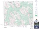
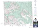
Maps showing Divide Pass, Alberta
Divide Pass is a Valley located in Alberta and has an elevation of 2475 meters.
- Latitude: 51° 45' 4'' North (decimal: 51.7511110)
- Longitude: 115° 55' 50'' West (decimal: -115.9305556)
- Topography Feature Category: Valley
- Geographical Feature: Pass
- Canadian Province/Territory: Alberta
- Elevation: 2475 meters
- Atlas of Canada Locator Map: Divide Pass
- GPS Coordinate Locator Map: Divide Pass Lat/Long
Divide Pass NTS Map Sheets