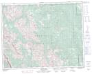
Maps showing Edworthy Falls, 2-20-8-W5, Alberta
Edworthy Falls is a Falls located in 2-20-8-W5, Alberta.
- Latitude: 50° 39' 58'' North (decimal: 50.6661110)
- Longitude: 114° 59' 47'' West (decimal: -114.9963888)
- Topography Feature Category: Falls
- Geographical Feature: Falls
- Canadian Province/Territory: Alberta
- Location: 2-20-8-W5
- Atlas of Canada Locator Map: Edworthy Falls
- GPS Coordinate Locator Map: Edworthy Falls Lat/Long
Edworthy Falls NTS Map Sheets