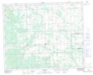
Maps showing Mud Creek, 10-37-6-W5, Alberta
Mud Creek is a River located in 10-37-6-W5, Alberta.
- Latitude: 52° 10' 8'' North (decimal: 52.1688888)
- Longitude: 114° 46' 17'' West (decimal: -114.7713889)
- Topography Feature Category: River
- Geographical Feature: Creek
- Canadian Province/Territory: Alberta
- Location: 10-37-6-W5
- Atlas of Canada Locator Map: Mud Creek
- GPS Coordinate Locator Map: Mud Creek Lat/Long
Mud Creek NTS Map Sheets