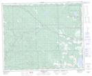
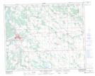
Maps showing Crimson Lake Provincial Park, 40-8-W5, Alberta
Crimson Lake Provincial Park is a Conservation area located in 40-8-W5, Alberta and has an elevation of 965 meters.
- Latitude: 52° 27' 57'' North (decimal: 52.4658333)
- Longitude: 115° 2' 44'' West (decimal: -115.0455556)
- Topography Feature Category: Conservation area
- Geographical Feature: Provincial Park
- Canadian Province/Territory: Alberta
- Elevation: 965 meters
- Location: 40-8-W5
- Atlas of Canada Locator Map: Crimson Lake Provincial Park
- GPS Coordinate Locator Map: Crimson Lake Provincial Park Lat/Long
Crimson Lake Provincial Park NTS Map Sheets