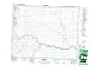
Maps showing St. Joseph's Industrial School Provincial Historic Site (Undeveloped), 21-28-W4, Alberta
St. Joseph's Industrial School Provincial Historic Site (Undeveloped) is a Conservation area located in 21-28-W4, Alberta.
- Latitude: 50° 48' North (decimal: 50.8000000)
- Longitude: 113° 47' West (decimal: -113.7832999)
- Topography Feature Category: Conservation area
- Geographical Feature: Provincial Historic Site
- Canadian Province/Territory: Alberta
- Location: 21-28-W4
- Atlas of Canada Locator Map: St. Joseph's Industrial School Provincial Historic Site (Undeveloped)
- GPS Coordinate Locator Map: St. Joseph's Industrial School Provincial Historic Site (Undeveloped) Lat/Long