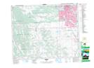
Maps showing Shaw Woolen Mill Provincial Historic Site (Undeveloped), 34-22-1-W5, Alberta
Shaw Woolen Mill Provincial Historic Site (Undeveloped) is a Conservation area located in 34-22-1-W5, Alberta.
- Latitude: 50° 55' North (decimal: 50.9166999)
- Longitude: 114° 4' West (decimal: -114.0667000)
- Topography Feature Category: Conservation area
- Geographical Feature: Provincial Historic Site
- Canadian Province/Territory: Alberta
- Location: 34-22-1-W5
- Atlas of Canada Locator Map: Shaw Woolen Mill Provincial Historic Site (Undeveloped)
- GPS Coordinate Locator Map: Shaw Woolen Mill Provincial Historic Site (Undeveloped) Lat/Long
Shaw Woolen Mill Provincial Historic Site (Undeveloped) NTS Map Sheets