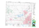
Maps showing Father Lacombe Chapel Provincial Historic Site (Developed), 4-54-25-W4, Alberta
Father Lacombe Chapel Provincial Historic Site (Developed) is a Conservation area located in 4-54-25-W4, Alberta.
- Latitude: 53° 38' North (decimal: 53.6332999)
- Longitude: 113° 38' West (decimal: -113.6332999)
- Topography Feature Category: Conservation area
- Geographical Feature: Provincial Historic Site
- Canadian Province/Territory: Alberta
- Location: 4-54-25-W4
- Atlas of Canada Locator Map: Father Lacombe Chapel Provincial Historic Site (Developed)
- GPS Coordinate Locator Map: Father Lacombe Chapel Provincial Historic Site (Developed) Lat/Long